GeoHistories

Co-Evolution of Earth and Life / GEOS 101 at Williams College

October 22, 2016
by Phoebe Cohen
Comments Off on Rock Scrambling and Bedrock: A Geohistory of Manhattan

Rock Scrambling and Bedrock: A Geohistory of Manhattan

by Mia Hull

The city of New York does not conjure up phantasmagorias of geology. A densely packed space, not much of the earth’s crust is visible on the surface of the city. In Manhattan, one can go weeks without seeing so much as a park. Central Park is one of the only places where the natural state of New York is exposed. Those rocks are remembered more fondly as a childhood climbing ground, than any sort of window into the past of the formation of the Earth. Yet the type of rock that makes up Manhattan Island is more intrinsic to its existence than anything else. Without Manhattan’s stable bedrock, the looming skyscrapers that are often conceived of as an integral part of its identity would not be supported enough to exist. It is interesting to consider how the formation of this particular part of North America, molded by the same processes as the whole globe, created such a unique city that is known for so many other things besides its geologic makeup and history.

The Taconian Orogeny, which occurred approximately 450 million years ago during the Middle Ordovician Time Period, is responsible for the formation of Manhattan, along with the creation of the Taconic Mountains and the deformity and metamorphosis of the rocks of southeastern New York (1). The Taconian Orogeny was a continent building event that occurred when the landmass we now consider North America and a volcanic island arc collided, and North America began to be subducted (or pulled under) the volcanic island arc. Volcanic “island arcs are volcanic islands that form parallel to ocean trenches in subduction zones.”(2). The volcanic island arc formed because of increased volcanic activity due to the plate tectonic movement that would go on to create Pangaea (3). Because of the immense amount of pressure being exerted on the rocks that made up North America during this partial subduction, they metamorphosed and folded together into the beginnings of the metamorphic rocks we know today. Metamorphic rock is one of the three major types of rock (the two others are Sedimentary and Igneous.) Metamorphic rock forms when any of the various types are subject to immense amounts of pressure and incredibly high temperatures that literally transform them into a new type of rock. Shale became schist, limestone became marble, and both were folded in with the granite gneiss that had already formed a billion years ago during another rock building event called the Grenville orogeny. In the present, Manhattan is formed by three warped strata (layers of rock) that fold into each other. The next event in New York City’s formation was the Acadian OrFigure 1ogeny, which occurred when North America collided with Avalon, a smaller continent, and they stuck together (4). Many more collision events happened to North America over the years, including the eventual formation of Pangaea, a global supercontinent, and its consequent stretching and pulling apart, each further deforming the rocks. Each of these events drastically twisted and upturned the rock layers to the point that is it very difficult to tell what collections of rocks and distortions belong to each event.
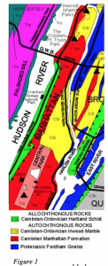
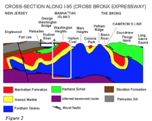
 The primary three strata, or layers of rock, (that I mentioned earlier) that form Manhattan are the Manhattan Schist, the Inwood Marble, and the Fordham Gneiss. Figure 1 gives you a bird’s eye of the surface distribution of these three types of rock in most of Manhattan. The yellow represents the Inwood Marble, the red represents the Manhattan schist, and the blue represents the Fordham Gneiss. Allochthonous Rocks are rocks that have been moved from their site of creation, while Autochthonous Rocks are rocks that are still in their original site (even if they have been eroded and deformed since then.) Although only a sliver of blue is visible on Manhattan in this map, as you can see it reappears on the opposite side of Queens, which purely from this map, implies that the gneiss seems to be at the bottom of the East and Harlem River. This opinion is supported by the next Figure (2), which displays a cross section along the top of Manhattan of the make up of the various rock layers. It is fascinating to see the layers extending into New Jersey and the Bronx (Manhattan is represented in the light gray box. Also the gneiss that so little can be seen of on the surface forms the majority of the rock in the area. The hilly formations that one might notice in Figure 2 are due to erosion between periods of glaciation.5 TheFigure 2 Inwood Marble, by far the thinnest layer, is the softest rock and therefore the most susceptible to erosion. The Inwood Marble is responsible for many of the rocks I scrambled over as a child and napped on in the sun.
The only fossils to be found in New York City are in museums: fossils can only form in sedimentary rock and Manhattan is made up of metamorphic rock, which has been compressed to the point that any fossils that once could have been found are now gone.

Geology is of special importance to New York City because of the knowledge required of it for engineering. The strata began to be uncovered in the area with the 1817 construction of the Erie Canal (6). Because New York City is in a constant state of construction, endlessly building new subway lines and high-rise foundations, it has a unique opportunity to keep track of the strata. Askins and Grevin put forward a proposal to establish a repository of the metropolitan subsurface geology, which in their opinion is useful not only because of the geohistory of Manhattan that it paints a picture of, but because it gives them a working picture of how rocks are being affected in the short term (7). There is a current debate going on about the extent to which the depth of Manhattan’s bedrock has actually affected its skyline, but it is safe to say that without the metamorphic makeup of the bedrock, which has already been subjugated to enormous pressure and completely compressed, Manhattan would not be able to support its skyscrapers without the rock shifting around. Manhattan’s close relationship with its rocks has been far more influential than just its visible Central Park climbing rocks would imply. But scrambling over rocks is pretty fun.


1 Isachsen, Yngvar. W. Geology of New York: A Simplified Account. Albany, NY (89 Washington Ave., Albany 12234): New York State Museum/Geological Survey, State Education Dept., U of the State of New York, 1991. Print. p. 50.

2 Island Arcs. (n.d.). Retrieved December 4, 2014, from http://www.kids-fun-science.com/island-arcs.html

3 McCully, Betsy. “New York Geology.” New York Geology. N.p., Aug. 2011. Web. 16 Nov. 2014. <http://www.newyorknature.net/Geology.html>.

4 Isachsen, Yngvar. Ibid. p 50.

5 “Geology of National Parks.” Geology of National Parks. N.p., n.d. Web. 16 Nov. 2014. <http://3dparks.wr.usgs.gov/nyc/highlands/manhattan.htm>.

6 Isachsen, Yngvar. Ibid. p 240.

7 Dennis, Askins H., and Grevin J. Frederick. “Proposal to Establish a New York City Soil and Rock Core Repository Representative of Metropolitan Subsurface Geology.” Northeastern Geology and Environmental Science 26.1-2 (2004): 2-4. GeoRef. Web. 16 Nov. 2014. <http://www.geocities.com/northeasternscifdn/>.

Figure 1

“Geologic Map of Northern Manhattan and the Bronx.” USGS. N.p., n.d. Web. 16 Nov. 2014.

<http://3dparks.wr.usgs.gov/nyc/highlands/manhattan.htm>.

Figure 2

“Simplified Cross Section of Northern Manhattan and the Bronx along I-95.” USGS. N.p., n.d. Web. 16

“Geologic Map of Northern Manhattan and the Bronx.” USGS. N.p., n.d. Web. 16 Nov. 2014.

<http://3dparks.wr.usgs.gov/nyc/highlands/manhattan.htm>.
January 29, 2015
by Phoebe Cohen
Comments Off on Geologic History of the North Shore of Boston, MA

Geologic History of the North Shore of Boston, MA

Jocelyn Wexler

            I attended an elementary school on the North Shore of Boston, a region encompassing coastal towns and cities stretching from Boston to New Hampshire. The boundary between my elementary school and the forest behind is lined with rocks. My childhood memories are full of this rock wall. Crossing this line of rocks was against the rules; so obviously, my classmates and I spent all of our time crawling over them, dying to go into the forbidden forest behind the boundary. Most of these rocks had been moved there to make the wall; however, the largest one, stuck deeply in the ground, had not been put there by humans. When I was younger, I always wondered how this rock got there.

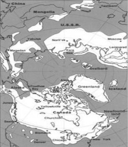
Figure 1: The Laurentide Ice Cap in North America, including its coverage of Massachusetts (U.S. Geological Survey).

Figure 1: The Laurentide Ice Cap in North America, including its coverage of Massachusetts (U.S. Geological Survey).

One of the questions I should have asked myself about the rocks around me is where the rocks underneath my feet came from. The North Shore is the product of hundreds of millions of years of geologic events. It is part of an exotic terrane, a piece of land that originated from elsewhere (Raymo & Raymo, 2007). The North Shore’s exotic terrane is called Avalonia. Avalonia is a volcanic island arc that most likely came from Gondwana, a supercontinent, which is a landmass made up of multiple continents (Thompson, Grunow, & Ramezani, 2010). Around 550 million years ago, a process called plate tectonics caused Avalonia to break off Gondwana and head towards proto-North America (Goldner & Allen, 2009). Plate tectonics are driven by the hot convective mantle deep in the Earth and cause landmasses to move over the globe (Raymo & Raymo, 2007). About 400 million years ago, during the Devonian Period, plate tectonics also caused a mountain building event known as the Acadian Orogney. In the Acadian Orogoney, Avalonia was crushed between Baltica, modern day Europe, and proto-North America as they collided and Avalonia accreted onto proto-North America (The Teacher-Friendly Guide to the Earth Science of Northeastern US), (Raymo & Raymo, 2007). This crush turned some of the igneous rock that made up Avalonia into metamorphic rock, which is rock changed by high heat and high pressure (The Teacher-Friendly Guide to the Earth Science of Northeastern US). The Continue Reading →

January 29, 2015
by Phoebe Cohen
Comments Off on Indiana Limestone: A Short Biography

Indiana Limestone: A Short Biography

By Benjamin Williams

The somewhat sleepy Midwestern college town of Bloomington, Indiana, has only ever provided the setting for one movie. Fortunately for my hometown, that movie won an Academy Award. In Breaking Away (1979), four blue-collar youths band together to win a famous local bicycle race. They call themselves the “Cutters,” after the generations of stonecutters who worked in the limestone quarries around Bloomington. For most of a century, those quarries (see Figure One) were the primary industry of south-central Indiana.

Figure One: Rooftop Quarry, outside Bloomington, IN. Quarries like this one sustained the economy of south-central Indiana for a century. Source: Wikipedia

Figure One: Rooftop Quarry, outside Bloomington, IN. Quarries like this one sustained the economy of south-central Indiana for a century.
Source: Wikipedia


The rock that once made south-central Indiana prosperous continues to give the region its shape. Known the Salem Limestone, this geological formation is a uniform outcrop of pale stone that lies directly beneath the surface of much of southern Indiana; in some places, it reaches thirty meters in depth (Ambers 246). The shape of this limestone formation, together with that of the siltstone that intermingles with it, is responsible for the unpredictable landscape of my home.

Continue Reading →

January 16, 2015
by Phoebe Cohen
Comments Off on A Geohistory of London

A Geohistory of London

By Christa Rousseva

Today, London is a so vast a metropolis that it is easy to forget how just a few thousand years ago, nothing even remotely similar existed on the same ground that is now buzzing with all sorts of cosmopolitan life. The landscape has at times seen stretches of desert covering the entire nation and at other times glacial ice sheets expanding to the edges of East London.   

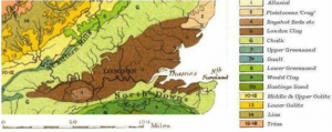
The landmass of England, entirely contained in the prehistoric land mass called Avalonia, has gone through great climatic and geographical changes since the formation of the Earth, some 4.5 billion years ago. Around 520 million years ago, the area that is today known as London was not even remotely close to where it is positioned now[i]. Avalonia was originally in the Southern Hemisphere and since that time has gradually drifted northwards to its current location.[ii] This northern movement has exposed London to numerous climates that are far from the perpetual rainfall the city is famous for today. In fact, over its expansive history, the landscape of Avalonia has transformed drastically. It has been an arid desert, covered in tropical forests, frozen over and even at the bottom of warm seas.

Fig. 1  The Geology of the London Basin

Fig. 1 The Geology of the London Basin

Continue Reading →

March 15, 2014
by Phoebe Cohen
Comments Off on Geological History of Greenwich, CT

Geological History of Greenwich, CT

By Meagan Goldman

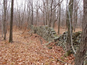
In the backcountry of Greenwich, CT, narrow roads twist and turn and rise and fall through the woods. If you peer into the passing trees, you’ll see vestigial structures that at first might perplex you: stonewalls. They’re everywhere. Millions of rocks piled into neat walls between waist-high and chest-high, crisscrossing through the woods, bordering roads, forming fences around nothing but trees and fallen leaves.

 Figure 1. A Stonewall in Connecticut woods. (Source: www.stonewall.uconn.edu/Classification.htm)

Figure 1. A Stonewall in Connecticut woods.
(Source: www.stonewall.uconn.edu/Classification.htm)

Built by farmers coping with the rocky Connecticut soil, the stonewalls in my hometown are remnants of settlements that no longer exist. Walking in the woods and passing stonewalls that lead nowhere, I often imagine the fields that used to exist where I stand, the cows or sheep that roamed, the crops that grew. But the stonewalls of Greenwich tell about more than human history; they also tell about geological history.

Continue Reading →

March 15, 2014
by Phoebe Cohen
Comments Off on Where the Mountains Meet the Plains

Where the Mountains Meet the Plains


By Luke Costley

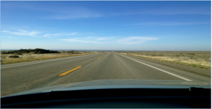
As I drove north on State Highway 75, I found an Idaho that I was not expecting. I was on my way to Ketchum for a year of Nordic skiing and my cross-country drive had taken me from the green hills of New England, through the Midwest to Nebraska and the endless monotony of southern Wyoming. A brief spell of Rocky Mountains in northern Utah had reassured me I was still headed west, but as I crossed the border into Idaho I was completely disoriented. Road signs said I was close to Ketchum, but nothing about the surrounding environment could have told me that. I was on a massive plain of charred black rock. The road stretched straight out in front of me. Where were the mountains from the pictures? Where was I going to ski? Most importantly, where were all the people?

The view headed north toward Ketchum

The view headed north toward Ketchum

But as I crested a small rise on the otherwise featureless landscape, I saw what I was looking for. Mountains rose out of the plain without warning or pretense; the rocky outcroppings faded then returned then faded again, giving way to chaparral flats and sagebrush; rugged outcroppings were interwoven with gentler hills; in my rearview, one world; in front of me, another. I was surprised by the Idaho I found because quite simply, Idaho is surprising. Continue Reading →

March 15, 2014
by Phoebe Cohen
Comments Off on Geological History of Long Island

Geological History of Long Island

By Didier Jean-Michel

My hometown, West Hempstead, New York, lies on Long Island, a landmass with an interesting geological history just east of New York City. Summers on Long Island were the best, with sandy beaches or rocky shores not far away. While the island today is most suburbanized (asphalt: everywhere), there is still a lot of evidence of its geological history.

Long Island’s “basement” bedrock is 230 to 350 million years old and is made of metamorphic rock (Merguerian and Sanders 4). The upper portion of Long Island’s geological layers were formed between the Upper Cretaceous Period (72 to 100 million years ago) and Pleistocene Epoch (.12 to 2.5 million years ago), and consists of mostly sedimentary elements: gravels, sand, and clay (see Bedrock Geology map here, provided by RegentsEarth) , which were all deposited by glaciers (M and S 5). This is a stark difference from New York City, which is located on a more solid rock. This is why taller skyscrapers can be built in Manhattan, but tend not to be on Long Island.

Continue Reading →

March 15, 2014
by Phoebe Cohen
Comments Off on A Granite History

A Granite History

By Abby Kelly

Rocks enjoy a special distinction in New Hampshire. Our official nickname is the Granite State, and our license plates and state quarters proudly display the rocky features of the Man on the Mountain (despite the fact that he’s been gone for several years). Not surprisingly, the dominant rock of New Hampshire is granite, a tough rock with visible quartz, mica and feldspar crystals. A walk down my road, as in many areas of New Hampshire, reveals granite fieldstones piled in stone walls, granite mailbox posts, granite front steps, granite foundations, granite countertops… the list goes on.

So where did all this rock come from? If we look back through time far enough, we see the atoms that now make up our planet getting spit out of exploding stars. The heavier elements were made in these massive stellar explosions, called super novae. Our sun formed from the leftovers of other suns, and its gravity slowly collected a swirling mass of cosmic dust. The gravity of the dust started clumping bigger and bigger pieces together, until planets formed. By 4.55 billion years ago, the Earth had taken shape, its core molten from the leftover energy of the planet’s formation. Denser elements like iron sunk deep into the center of earth, while the lighter elements (like those that make up granite) slowly cooled into a crusty surface layer. Currents of magma within the Earth brought lava to the surface in fiery volcanoes, releasing enough steam with the molten rock to begin forming the oceans as it condensed. As the oceans formed, so did the continents. Some parts of the crust became waterlogged and dense enough to slip back down into the Earth’s liquid mantle (the middle layer, between the crust and core). In other areas, upwellings of magma pushed new rock onto the continental crust. Between these two forces, great plates of the Earth’s crust started to shift in a process called plate tectonics, grinding into each other and piling up mountainous continents. Continue Reading →

June 5, 2013
by Phoebe Cohen
Comments Off on Geological History of Orono, ME

Geological History of Orono, ME

By Siobhan Harrity

My hometown of Orono, Maine is located in Penobscot County. I grew up gardening, and there is not a whole lot to do in the entire state of Maine except mess around outside, so I’ve been intimately acquainted with my local soil and rocks for years. However, I didn’t know much about where it had come from. Some digging around of a less literal kind turned up the following information.

The local bedrock is called the Vassalboro Formation, which is predominantly a bluish gray sandstone of Silurian-Ordovician age, or approximately 450 million years old (USGS). The rock has been deformed to varying degrees by several different tectonic events. Orono is located in the Norumbega fault zone. The Norumbega fault is a (now inactive) strike-slip fault, meaning that two different pieces of crust used to move past each other horizontally. It also marks the boundary between the Gander and Avalon terranes, two different, formerly discrete chunks of continental crust (Ludman 413). The fault can be traced from New Brunswick as far south as Connecticut (Caldwell 26), and it divides two regions with markedly different rock types. The Gander terrane, on which Orono sits, is made up of Silurian and Devonian mud and sandstones, whereas the Avalon terrane is composed of sedimentary rocks of varying ages and igneous granite plutons, or pockets of rock that formed when magma cooled at the surface (Caldwell figure 24). The Gander terrane can also be found in various locations in Africa, including Morocco. Rifting in the supercontinent Gondwana caused a fragment to break away, and it was carried across the ocean until it collided with the proto-North American continent (called Laurentia) during the Early Silurian. Any time two pieces of continental crust collide, mountains form. This type of event is called an orogeny, and this event in particular is called the Salinic (Miall and Blakely 6) or the Penobscot (Caldwell) Orogeny. During the Acadian Orogeny in the Devonian period, the last of the dense crust of the Iapetus Ocean floor was subducted into the mantle. This brought the Avalon terrane into contact with Laurentia just to the east of where Orono is today (Caldwell 9).

Continue Reading →

June 5, 2013
by Phoebe Cohen
Comments Off on A Geological History of the Powder River Basin

A Geological History of the Powder River Basin

by  Meg O’Connor

This summer, I worked at Paradise Dude Ranch in Buffalo, Wyoming, a town about three and a half miles Southeast of Yellowstone National Park. When I was first picked up at the airport by two haphazard-looking men, I had the sudden feeling that I was making a terrible mistake. The road to the ranch was long and winding, we lost cell phone service twenty minutes into the drive, and the nearby mountains, surrounding us in every direction, gave me the feeling that I could never get out, even if I wanted to.

As it turns out, I was not making a terrible mistake, but all those times that I loped across the mesa, got trampled by cows, and fished for rainbow trout in the creek, I did these things framed by the backdrop of The Bighorn Mountains, which never lost their feeling of being powerful and constraining. And every time that we sang the John Denver song “Country Roads Take Me Home” during the weekly ranch sing-a-long, the line, “Life is old there, older than the trees, younger than the mountains, blowin’ like a breeze” stuck out in my mind. As a geology student, I couldn’t help but wonder… how old are all these things, actually? Somehow, I don’t think John Denver had the answer, but I’m hoping to find out a little more about that in this post.

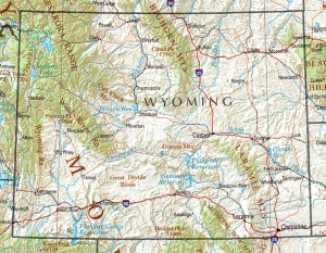
As I drove on the ranch road to Buffalo, part of the reason I felt so constrained is that the ranch is surrounded by the Powder River Basin at the foot of the Bighorn Mountains, which lie to the West. To the East lie the Black Hills. They were out of the view of the ranch but still added to the feeling of being sunk low into the ground and surrounded by uplifted mountains—though objectively speaking, “sunk” isn’t really the right word.

Map of the Powder River Basin

Map of the Powder River Basin

The Ranch’s elevation initially felt significant at just under 8,000 feet. Even higher than that stood the nearby Bighorn Mountain Range—most notably Cloud Peak, which could be seen distinctly from the ranch’s mesa—reached nearly 14,000 feet. The Bighorn Mountains were uplifted during the Laramide Orogeny, a mountain-building event that occurred 70 million years ago during the Cretaceous period. Cloud Peak contains an active glacier that could be seen as a white ice cap from the ranch. It is called the Cloud Peak Glacier and rests on the eastern slope, which is the slope visible from the mesa.

The Powder River Basin was formed when the Bighorn mountains and Black Hills created by the Laramide Orogeny spread away from each other, creating a rift valley that then filled and drained with water  repeatedly throughout its history. The edges of the basin are made up of marine sediment from the Cretaceous period, when the climate warmed, and the area was underwater. Some other significant layers in the rock stratigraphy are a layer of Bighorn Dolomite from the Ordovician, an upper Devonian deposition of limestone, and mostly depositions of different shale formations from the late Cretacious on. Slate  is mudstone that has been metamorphosed, or subjected to a large amount of pressure or heat, which is often found at river deltas. It breaks very easily along its sheets. The shale in the Powder River Basin might have been formed by sediment from the Powder River itself. We didn’t see much of the Powder River at the Ranch; the body of water that impacted the ranch more heavily was the French Creek, which even our saloon was named after! French Creek provided most of the irrigation for the ranch, and runs along the base of the Bighorns. A stratigraphic section of the Powder Creek Basin can be found at the Wyoming Geological Survey website.

A common type of rock found in this basin is called “scoria” colloquially  known as “red dog,”. It is red from oxidation of iron, which causes the rock to rust. The area is rich in coal, and the coal sometimes burns naturally due to lightening or forest fires. As the coal burns, it “bakes” the red dog rocks and turns them into sturdy structures that are more resistant than usual to erosion. This phenomenon probably contributed to the amazing rock structures that could be found around the ranch and the rest of the basin. Most notably on the ranch itself was Fan Rock, a structure that “fanned out” over one of our pastures. It is reddish in color and is noteworthy for its distinct, jagged edges which are less eroded than the rounded sides in other parts of the mountain. Forest fires are common to the area and led to a great deal of scoria formation in the area.

Fan Rock

Fan Rock

I have referred to the mesa several times—a beautiful, flat patch of land above tree level where we did most of our difficult riding, hiking, and stargazing. Mesas are formed by erosion and weathering, or the wearing away of sediment deposits in uplifted land. Likely, the land that composes the mesa was uplifted by the Laramide Orogeny, but over time, the softer layers like the shale were eroded away, leaving the stronger rocks like the baked red dog. The strong rocks flattened out over time, leaving the great expansive mesa in its wake. The mesa showed evidence of “cliff and bench” topography, or areas of gradual higher and lower elevation due to differences in rock types.

Fossils are quite common in Wyoming and in the Powder River Basin. In “Late Ordovician Vertebrates from the Bighorn Mountains of Wyoming, USA,” Sansom and Smith discuss having found fish fossils in the Bighorns from the Ordovician. During the Paleozoic, when Wyoming was covered by a shallow sea, many ancient marine animals lived there and are now fossilized. You can even find dinosaur fossils in this area! Since the sea level was constantly rising and falling, it created an atmosphere conducive to fossilizing organisms, mostly because of the shallow water.

On Paradise’s website, a famous author, Owen Wister, is quoted as saying, “Finally, there was Paradise Ranch, an obvious platitude when read from a map, but something quite different when you arrived there at the end of a hard ride. It lay tucked away on the far side of a high peak, as any proper Paradise should.” Although I disagree, from the standpoint of a geologist, that Paradise is a “platitude,” on a map, there are certainly some aspects of the Powder River Basin that are awe inspiring in person because of its unique geologic history.


Work Cited

Sansom, Ivan and Smith, Paul. ” Late Ordovician vertebrates from the Bighorn Mountains of Wyoming, USA.” Paleontology. The Paleontological Association, January 2005. Web.

Worland and Tensleep Visitors’ Council. http://www.tensleepworlandwyoming.net.

Wyoming State Geological Society, http://www.wsgs.uwyo.edu. Digital Geologic Units (Surficial Map) of Yellowstone National Park and Vicinity, Wyoming, Montana and Idaho (NPS, GRD, GRE, YELL, YELLGLG). 2007.

http://www.paleoportal.org  (Created by the University of California Museum of Paleontology, the Paleontological Society, the Society of Vertebrate Paleontology, and the United States Geological Survey).