By Christa Rousseva
Today, London is a so vast a metropolis that it is easy to forget how just a few thousand years ago, nothing even remotely similar existed on the same ground that is now buzzing with all sorts of cosmopolitan life. The landscape has at times seen stretches of desert covering the entire nation and at other times glacial ice sheets expanding to the edges of East London.
The landmass of England, entirely contained in the prehistoric land mass called Avalonia, has gone through great climatic and geographical changes since the formation of the Earth, some 4.5 billion years ago. Around 520 million years ago, the area that is today known as London was not even remotely close to where it is positioned now[i]. Avalonia was originally in the Southern Hemisphere and since that time has gradually drifted northwards to its current location.[ii] This northern movement has exposed London to numerous climates that are far from the perpetual rainfall the city is famous for today. In fact, over its expansive history, the landscape of Avalonia has transformed drastically. It has been an arid desert, covered in tropical forests, frozen over and even at the bottom of warm seas.

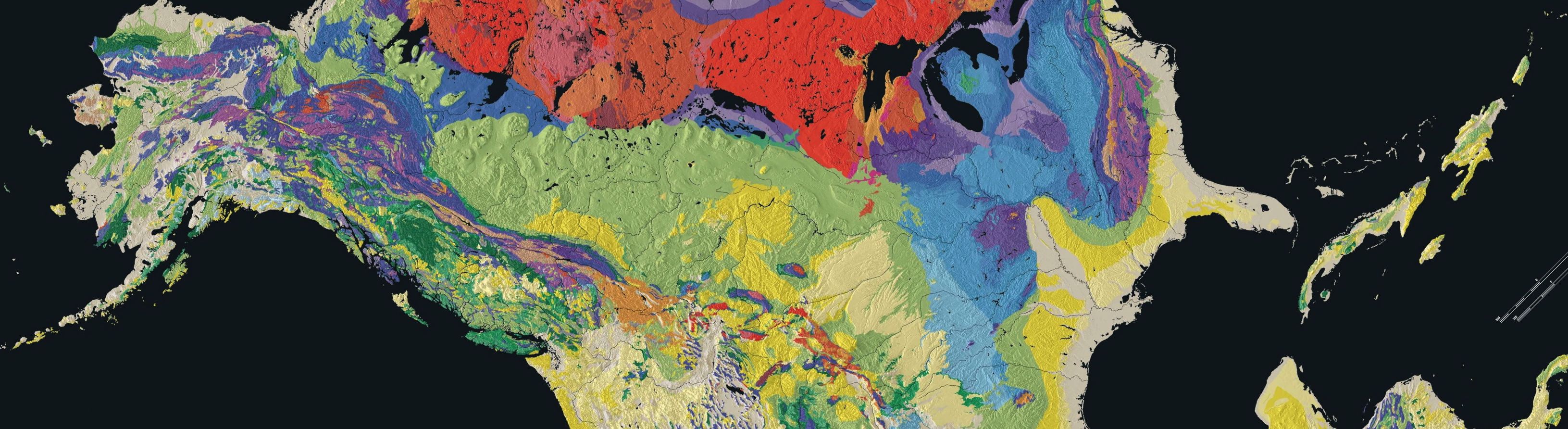
Fig. 1 The Geology of the London Basin
The two main rocks on which the central London area is built are sedimentary.[iii] One is chalk that formed during the Cretaceous Period (approx. 145-66 million years ago) and the other, known as London Clay, is from the Palaeogene period that ended 23 million years ago[iv]. The formation of these two sedimentary rock types occurred in deep, warm seas during the Cretaceous and Palaeogene Period, when tropical seas dominated this part of England. The white, fine-grained limestone chalk is composed of the calcite shells of a species of microscopic plankton called Coccolithophores[v]. One of the most famous outcrops of this chalk in England are the White Cliffs of Dover, reaching 170m in height above sea level, that are best seen when crossing the English Channel into Calais, France via ferry. It is rumoured that Winston Churchill had private offices built into the cliffs and during the War he would sit there looking out into France. In London, this chalk reaches 70m below the Palace of Westminster, the meeting place of British Government.
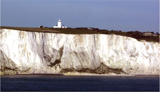
Fig. 2 The White Cliffs of Dover
The other dominant rock type, London Clay, consists of much finer particles, smaller than sand. The presence of this clay, as thick as 45m beneath the borough of Westminster, has to a certain extent facilitated London’s notoriety as one of the best transport hubs in the world. This clay is very easy to tunnel through and so the Underground Network has been hugely shaped by it. North of the River Thames, the clay sediments are closer to the ground’s surface, which is why the Tube network is significantly more extensive in the northern parts of London than in the southern.
London’s geographical history as a tropical sea is due to its previous equatorial location. This meant the coastline was subtropical therefore explaining the presence of some of the fossils that have been discovered. There is a diverse collection of plant fossils excavated from London; one of the most abundant type of fossil is that of mangrove trees that once composed tropical forests resembling those today found in Indonesia.[vi] London was also once home to mammals such as mammoths and woolly rhinos in its Ice Ages, the most recent one occurring just 400,000 years ago during the Pleistocene[vii].
It is this Ice Age, during the Pleistocene, that paved the formation for the River Thames and centuries later made it a desirable settlement location and millennia later allowed London to flourish as a trading epicentre. When sea levels regressed at the initial stages of the glaciation period, a part of what is today considered the River Thames became the dominant drainage line along the seafloor[viii]; this drainage line can be traced back 58 million years to the Late Neogene. At the height of this Ice Age, the ice sheet extended as far as East London where it formed a dam in the river thereby blocking water flow and creating ice lakes. The pressure exerted from the dam eventually collapsed and the lakes’ banks burst diverting the river’s course onto its present day one[ix]. Additionally, as these ice sheets melted they carried large volumes of material into the water that added to the sedimentary base of the river. This glacial water also increased water volume of the river significantly therefore solidifying the transition of drainage system to river[x]
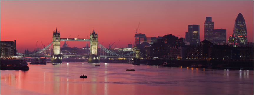
Fig. 3 The River Thames in Central London
Indeed, the landmass that is now known as London boasts an impressive and diverse geohistory, so much so that it is difficult to conceive such large time scales. It is this rich history, however, that has today made the city into what it is. Just a few small changes and there wouldn’t have been such a diverse underground network or no world-famous River Thames!
[i] Glaciation and geological timescales – London: Its geological journey and heritage. (n.d.). Retrieved November 13, 2014, from http://www.rgs.org/OurWork/Schools/Teaching resources/Key Stage 3 resources/Glaciation and geological timescales/London – its geological journey and heritage.htm
[ii] Glaciation and geological timescales – London: Its geological journey and heritage. (n.d.). Retrieved November 13, 2014, from http://www.rgs.org/OurWork/Schools/Teaching resources/Key Stage 3 resources/Glaciation and geological timescales/London – its geological journey and heritage.htm
[iii] Geology of Britain viewer | British Geological Survey (BGS). (n.d.). Retrieved November 13, 2014, from http://mapapps.bgs.ac.uk/geologyofbritain/home.html
[iv] Glaciation and geological timescales – London: Its geological journey and heritage. (n.d.). Retrieved November 13, 2014, from http://www.rgs.org/OurWork/Schools/Teaching resources/Key Stage 3 resources/Glaciation and geological timescales/London – its geological journey and heritage.htm
[v] London Geology Overview. (n.d.). Retrieved November 13, 2014, from http://www.rgs.org/OurWork/Schools/Teaching resources/Key Stage 3 resources/Glaciation and geological timescales/London – its geological journey and heritage.htm
[vi] London Geology Overview. (n.d.). Retrieved November 13, 2014, from http://www.rgs.org/OurWork/Schools/Teaching resources/Key Stage 3 resources/Glaciation and geological timescales/London – its geological journey and heritage.htm
[vii] Imbrie, J. (1985). A theoretical framework for the Pleistocene ice ages. Journal of the Geological Society of London, 142(3), 417-432. doi:10.1144/gsjgs.142.3.0417
[viii] Bridgland, D., & Bowen, D. (1994). 3. In Quaternary of the Thames. Dordrecht: Springer Netherlands.
[ix] Bridgland, D., & Bowen, D. (1994). 3. In Quaternary of the Thames. Dordrecht: Springer Netherlands.
[x] Bridgland, D., & Bowen, D. (1994). 3. In Quaternary of the Thames. Dordrecht: Springer Netherlands.
Images:
Fig 1. “Geological map of London Basin” by Pterre after Horace B Woodward – Adapted from Geological_map_of_Great_Britain.jpg. Licensed under Public domain via Wikimedia Commons – http://commons.wikimedia.org/wiki/File:Geological_map_of_London_Basin.jpg#mediaviewer/File:Geological_map_of_London_Basin.jpg
Fig 2. “Douvres (6)”. Licensed under Creative Commons Attribution-Share Alike 3.0 via Wikimedia Commons – http://commons.wikimedia.org/wiki/File:Douvres_(6).JPG#mediaviewer/File:Douvres_(6).JPG
.JPG#mediaviewer/File:Douvres_(6).JPG)
Fig 3. “London Thames Sunset panorama – Feb 2008” by Diliff – Own work. Licensed under Creative Commons Attribution 3.0 via Wikimedia Commons – http://commons.wikimedia.org/wiki/File:London_Thames_Sunset_panorama_-_Feb_2008.jpg#mediaviewer/File:London_Thames_Sunset_panorama_-_Feb_2008.jpg