
Postcard 1: Map of the Tibetan Empire

The map of the Tibetan Empire was intentionally drawn on top of a contemporary map which showed an overlap of Tibet’s territory with the geographical borders of modern states surrounding Tibet. Premodern Tibet held a traditional worldview with no imperative to define boundaries, and its communities were bounded as one national entity through cultural allegiance and sentiments as opposed to claims over physical territories (McGranahan 40). This postcard of a Tibet map inspires people to reflect on the construction of a modern map, which assumes that all states consider defined frontiers as part of their state identity and state-making process. The Tibetan Empire covered geographic areas that transcended beyond the current geographical borders of the autonomous Tibet region, yet the current Tibet is unable to reclaim the lands for it would inevitably confront other modern states such as China.
Sources:
McGranahan, Carole. “Empire and the State of Tibet.” In Arrested Histories: Tibet, the CIA, and Memories of a Forgotten War, 37–52. Duke University Press, 2010, 40.
Javierfv1212. Map of the Tibetan Empire at Its Greatest Extent between the 780s and the 790s CE. March 29, 2011. Accessed December 15, 2022. https://commons.wikimedia.org/wiki/File:Tibetan_empire_greatest_extent_780s-790s_CE.png.
Postcard 2: British Expedition to Tibet

This French drawing created in the year of the British expedition to Tibet (1904) vividly portrays diplomatic interactions between Tibetans, British, and Chinese soldiers who met in Tibet to discuss Tibet’s strategic location regarding the Great Game between Britain and Russia. This event marked the beginning of Tibet’s exposure to the Western powers with their concepts of political structures and modernity. It was through this event that Britain realized the complex and unique relationship between Tibet and China was beyond their European knowledge structure, preventing them from seeking imperial interests in Greater China. As the drawing records the power dynamics among the three parties, it also symbolically represents the emergence of the Tibet question in a historical context.
Sources:
Unknown author. La Conquête Du Tibet: Entrevue D’officers Anglais Avec Les Tibétains. Le Petit Journal, February 14, 1904. Accessed December 15, 2022. http://www.gettyimages.com/detail/89862955/Hulton-Archive.
Postcard 3: The Tibetan People Welcome the People’s Liberation Army
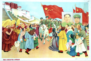
Understanding this drawing as a Chinese propaganda work provides historical context to the significance of this postcard. In the drawing, the artist depicted Tibetan people and lamas wearing traditional clothes to welcome the PLA. It was part of China’s national narrative that the PLA entered Tibet to “liberate” and “modernize” the inferior Tibetans who struggled with poverty and a premodern society. It not only made no comment on the massacre or acts of violence during the process of “liberation”, but also conveyed the CCP’s belief that Tibet could not exist as a modern state and needed China to incorporate it into China’s territory for a better future. I intentionally chose drawings (both this one and the previous one) that only showed the perspectives of China and Britain to suggest how these two countries erased Tibet’s participation in modernity and its agency in history, making it a “nowhere” and its people “no ones” unseen in the hegemonic narratives constructed by modern states.
Sources:
Wang, Quanhui. “The Tibetan People Welcome the People’s Liberation Army.”. The Art Of Chinese Propaganda. Frank Langfitt, November 9, 2012. Accessed December 15, 2022. https://www.npr.org/sections/pictureshow/2012/11/16/164785930/the-art-of-chinese-propaganda.