
Postcard 1: Islands of Ferghana Valley

This map depicts exclaves and contested lands in the Ferghana Valley as an archipelago of disconnected islands in a sea of sovereign territory. While Uzbekistan, Tajikistan, and Kyrgyzstan are some of the most landlocked states on the contemporary world map—far from any body of water—movement to, from, and within these places is heavily restricted by different state actors. Inhabitants of Chon-Qora, Isfara, Sarvan, Shakhimardan, Sokh, and Vorukh experience these territories as islands within a sea of monopolistic sovereignty, the global norm.
Sources:
Generated in ArcGIS using hand-drawn shapefiles overlaid on Ferghana Valley
Postcard 2: Nebulous Rivers
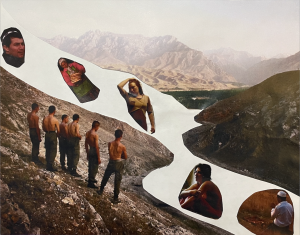
The foreground and background of this collage depicts a group of Uzbek soldiers surveying a territorial enclave within Ferghana Valley. Images of Uzbek, Kyrgyz, and Tajik citizens have been placed in a river of liminal space between the background and foreground elements. A river was chosen because surface water is the dominant water source for those living in Ferghana Valley. The river and citizens contained therein symbolize the precarious status imposed on inhabitants of contested territories by multiple sovereign states. Unlike the citizens nebulously floating in the unmarked river, the group of Uzbek soldiers occupy solid ground as enforcers of state sovereignty enabled to enact Weberian legitimate authority through violence.
Sources:
Created as physical collage of images taken by Jonas Bendiksen and Carolyn Drake
Postcard 3: A Sovereign Landscape
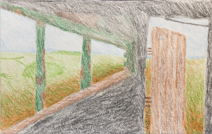
This color pencil sketch depicts a landscape view from a guard outpost near the Tajik-Afghan border, originally photographed by Carolyn Drake. The artwork seeks to place the viewer in the position of an enforcer of sovereignty willing and capable of making territorial claims on the observed landscape. While the early 21st century world map configures territory as an empty object to be occupied by state sovereignty, the artistic medium of colored pencils underscores the arbitrary and precarious nature of this fundamental assumption in modern nation-states.
Sources:
Created as a hand-drawn image in colored pencil to resemble Drake’s Nizhny Panj photo
Works Cited:
Bendiksen, Jonas. 2002. Ferghana Valley, border between Uzbekistan and Kyrgyzstan. An Uzbek border patrol surveys one of the valley’s seven territorial enclaves. The myriad borders of the valley make it hard to control. https://library.artstor.org/asset/AMAGNUMIG_10311525580.
Bendiksen, Jonas. 2002. Ferghana Valley, Osh, Kyrgyzstan. An Uzbek man conducting his evening prayers on the Kyrgyz border. https://library.artstor.org/asset/AMAGNUMIG_10311525628.
Bendiksen, Jonas. 2002. Ferghana Valley, Osh, Kyrgyzstan. Heroin addicts in Osh, where a dose of the drug costs less than a beer. https://library.artstor.org/asset/AMAGNUMIG_10311525590.
Drake, Carolyn. 2009. Ferghana Valley, Isfara, Tajikistan. Bread is one the few fresh products in abundant supply at the central market. https://library.artstor.org/asset/APANOSIG_10313568121
Drake, Carolyn. 2010. Nizhny Panj, Tajikistan. Tajik border troops patrol the country’s long border with Afghanistan. Afghanistan and Tajikistan share a 1,300 kilometer border, most of which is rugged and poorly protected. The border is a major route for drugs being smuggled from Afghanistan to Russia and Europe. https://library.artstor.org/asset/AWSS35953_35953_37919827.
Weber, Max. 1919. “Politics as a Vocation” in Essays in Sociology. New York: Oxford University Press, 77-128.