Posted on November 20, 2009 in 10 Stetson Hall Parking Lot Woods by No Comments »

Eric Outterson

November 20th, 2009

Natural History of the Berkshires

History

This week, I began an examination of the past which extended beyond the speculation of past visits to the Stetson parking lot woods.  It began with a visit to the college archives to see if I could get a better look at my site through aerial photographs over time.  Linda Hall greeted me at the elementary school and asked “Are you Eric Outterson?”

When I responded affirmatively, she promptly handed me a large box with many folders.  She told me, “In this box we have folders of most of the aerial photographs of the campus, and folders of photos of areas of the campus labeled by their location.”  I stared at the intimidating box, and decided that the only way to get through it was to start opening the folders.

In the aerial photographs box I found a large collection of photographs extending from the 1930’s onwards.  Unfortunately for me, most of the aerial photography was of campus icons like Thompson Memorial Chapel, Griffin Hall or West College.  The small patch of woods that now makes up my site is situated behind Thompson Memorial Chapel and Griffin Hall.  As a result, many of the angles on my site were not great.  Most were photographs which cropped out the trees.

Though there was a slightly larger timeframe in which I could see my site, from the limited set of photographs that remains, aerial and otherwise, I have approximately 3 windows of time in which I could see my site well.

These were around 1900, 1941 and 1962.  There was also one illustration from 1889.  In the illustration, there was a small stand of trees immediately behind griffin hall (labeled 16) and behind Goodrich (Old Goodrich).

superoldmap

Williamstown, Mass. Drawn and published by L. R. Burleigh. Burleigh Lith. Est.

Burleigh, L. R. 1853?-1923. (Lucien R.), Troy, N.Y., 1889.

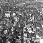
In later photographs, like those from around 1900.  In this photo dating before 1902 (we know that it’s before 1902 because the chemistry annex which is visible in the photo was removed from griffin hall), there is a shot of where my site was taken potentially taken by amateur photographer Cyrus Morris Dodd.

ViewofGriffinfromdodd

You can see goats in the picture grazing on the large stretch of land that is now the lower Stetson parking lot.  To determine where the current Stetson parking lot woods is, one must be careful, because in 1904 Griffin Hall’s foundation was moved 100 feet northeast.  After estimating the 100 foot move, it seems that in my site, you can see a few trees but nothing very lush.  It’s hard for me to guess what they might be exactly

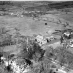
Looking ahead to 1941 it looks like there are more trees in the area that are my site.  It’s still difficult to identify any of them, but they do not look at all cultivated.

griffinlater

In photographs that follow, it seems that woods slowly gains more density even though the areas around it are always well cut by grasses and other things.

Between the founding of Williamstown in 1753 and the first visual evidence of the land being cleared in 1890, the trees were largely cleared.  I venture to guess that the trees were actually cleared much earlier, possibly around the 1830’s when Williamstown was at its agricultural land peak or in 1827 when Griffin Hall began construction.  After Griffin Hall’s construction, the land was largely cleared and used as pasture.

From 1900 onwards it seems the small number of trees increased quickly.  In photos of the Roeper center construction the stand of trees looks very thick, approximating what it looks like today.

Posted on November 20, 2009 in 08 Tyler House Woods by No Comments »

            My site, Tyler Woods is located just behind Tyler House. In the past, Tyler House used to be known as Psi Upsilon. The building was built where a previous building had once been in 1925 and was converted into a fraternity house. Tyler Annex was built much later in 1972. The Record reported that planning of the building began in October 3rd, 1925 and construction on Tyler House commenced on May 18th, 1926. Members of the fraternity named the house after one of its members: Lt. John Cowperthwaite Tyler (Warren, 55, 56).

            Tyler was a member of the Williams class of 1915. After he graduated from Williams College, he went to continue his education at M.I.T. Here, he studied aeronautics and mining and majored in engineering. He graduated from M.I.T. in 1917 and joined the French Escadrille Branch soon afterward. In 1918, he was sent to fly for the U.S. Army during World War I. While he was on a mission to bombing an enemy railroad, he and his comrades were attacked and his plane went down. This occurred on September 21st, 1918 (Warren, 55).

            Williams College received the right to use Tyler House as a residential facility in 1966 (Warren, 56), and that is what it is used as today. Thus, Tyler Woods has had at least a hundred years of exposure to human activity.

            Before the Tyler plot was owned by Williams College, it was most likely owned by the Huntoon family, specifically Eliza M. Huntoon. The deed to the land states, that the Huntoons had possession of the land in 1904 and at least until 1909. Although there is not that much information specifically relating to the ownership of Tyler Woods, it is possible that some of its nearby neighbors such as the Jeromes, Hewitts, and the Tenneys may also have owned parts of Tyler Woods since their properties bordered the woods according to a map created in 1904.

            I hope to be able to take a corer and determine how old some of the larger trees in my site are. This may give me a sense of how old the forest is. Was the forest here before the Huntoons obtained it in 1904?

            Not too far from Tyler Woods, Williams College also used to own a farm. Is it possible that Tyler Woods used to be a pasture or cultivated area? If this is true, then when did the forest begin to grow and take over?

Posted on November 20, 2009 in 09 Syndicate Road Woods by No Comments »

Syndicate Road Woods

Human History and Impacts


The Syndicate Road woods have an interesting human history from the origins of Williamstown, their association with the college and their use today.  Today, the woods are not maintained by humans, though their size is limited on the west by Syndicate Road and the east by the Poker Flats fields.  Their terrain, flora, and use in the past, however, seems to be very different than it is today. 

            The first piece of evidence we have is a map from 1843 plotting the original land divisions of Williamstown.  This map shows the original plots for each townsman, as well as areas coded as meadows, pine or oak forests, as well as the first and second 50 acre plots allotted to each member of the town.  Where the Syndicate Road woods now stand appears to be part of the “1st 50 acre” section.  This most likely means that an early settler cleared the land and used it for agricultural purposes.

            It appears that the Tallmadge family owned the land during this time, because there are records from 1887 documenting the sale of this land by the Tallmadge family.  The Tallmadges also owned a 72 acre farm plot in what is now the Hopkins forest to the west of the Hoosic River, and sold that land to Hopkins in 1889.  In 1887, according to the president’s report from that year, a group of men bought the Tallmadge land who planned on building a housing development.  A 1889 map shows that Park Street ended at Baxter Road, but the president mentions in his report that the men built Syndicate Road to connect Park Street with North Street.  This road was most likely a dirt path however, because a sketch from 1939 comments that the intersection with Baxter Road marked the “end of improved road.”  In the end, nothing came of the housing development and the area was sold to the College.  At the same time the Huntoon lot, which included lands east of Syndicate Road and the area that is now Cole Field, was sold to the College, and the land was then used as the college farm.  The area was still being used as farmland in 1938, as shown by the aerial photograph below.  The photograph shows the Thompson Infirmary and the Cole Field house, and the area that is now Cole Field and the Tennis Courts was plowed in sections of farmland.  Besides these landmarks there was very little vegetation, and it appears that one could see Eph’s Pond from Thompson because the area was not blocked by heavy forestation as it is today.  Note also that Syndicate Road is still just a dirt path marked by wheel tracks in this photograph.  To the east of this path, where the Syndicate Road woods site now exists, there were a few trees of an indiscernible species speckled along the road. 

            The next piece of pictorial evidence is an aerial photograph taken in 1962, also shown below.  Here, in only about a quarter century, the amount of foliage in the area has grown at least three-fold since the last picture was taken.  The tennis courts and Cole Field have been constructed, and it does not appear that the Poker Flats field is being used as farmland anymore.  The trees in the area seem to be a mix of both deciduous and coniferous, and at this point Syndicate Road has been paved and has become an official road.  Mission Park and the parking lots behind it were not built until 1971.

            The natural history of the Syndicate Road Woods is noticeable in the terrain of the woods today.  The trees represent those that are usually in existence in old areas of cultivation, especially paper birch, red oak, sugar maple, hemlock, beech and yellow and black birch.  There is little human impact within the woods besides the telephone lines that run north/south along Syndicate Road.  The Syndicate Road woods present an interesting history of a land that was once cultivated and is now very much untouched by human hands.         

Posted on November 20, 2009 in 07 Mission Park by No Comments »

Gordon Smith

Natural History of the Berkshires

11/17/09

Field Blog 8: Land Use History for Mission Park

The area that is now known as Mission Park has undergone several changes since colonial settlers first laid eyes on it.

The area that would be my site at Mission Park occupies an area at the north end of housing lots as shown on the original colonial plan for Williamstown that was drawn in 1749. To be more specific, I believe it occupies space touching on housing lots 48, 50 and 52.

For a long period of time between this 1749 map and 1806, it is believed that the area was a hay meadow that may have also been used for grazing animals. The flatness and smoothness of the topography of the current Mission Park also indicates that it was plowed for crops at some point as well during this period, though when is again uncertain.

Though Samuel Sloan was not the original owner of lots 48, 50 or 52, it is known that he acquired the property containing Mission Park sometime before 1806. This is clear because the area, before it was renamed, was known as “Sloan’s Meadow.”

In 1806, there was a fierce thunderstorm raging over Williamstown, and five students, including Samuel John Mills (class of 1809) were caught in the storm on their way back from a religious congregation. These young men took shelter under a haystack in Sloan’s Meadow, and while they were waiting out the storm, began to talk of the word of God. The course of their conversation led them to decide that they would start spreading the “Gospel on a global basis.” And in this way, the American Foreign Mission was born.

Almost 50 years later in 1854 the College Society of Alumni and the Board of Trustees decided to purchase 10 acres of the land surrounding the original haystack, and renamed the area “Mission Park or Grounds” as a historical park. In 1867, the marble Haystack Monument commemorating the 1806 event was raised in the park.

Since this time, there has been relatively little change to the overall land use of the area. Williams College has maintained the area as a historical park, which seems to have involved groundskeepers maintaining the surrounding area. Trees were grown and trimmed, and based on their diversity, it would not surprise me if at least some of them had been planted purposefully for aesthetic reasons. In addition, the area seems to have been kept for the most part clear of bushes, though it is uncertain how long this clearing has been taking place.

There also have been several building projects completed in Mission Park. In 1895/6, Williams Hall Annex was built in the area that currently contains the Mission Park dormitory. This building was used as an infirmary until 1911 when Thomson Infirmary was built to the north. It was converted into a dormitory by 1919, and was used as freshmen housing starting from 1922.

In 1926, the Theta Delta Chi fraternity house was moved next to Williams Hall Annex, and was renamed Sage Hall Annex. In consecutive years, the two buildings served a variety of purposes: football training housing, dining halls, housing for returning veterans and their families after World War II, and others. Eventually, Williams Annex was torn down in 1968, and it is believed that Sage Annex was moved off of Mission Park.

In the late 1960s through 1971, the current Mission Dormitory was constructed. Mitchell-Giurgola and associates designed the building, and in 1970 the clever architectural design of the building earned its builders a Progressive Architecture design award. The building was opened in 1971, and had cost the college $5,400,000.

As can be seen, the land of Mission Park has been for the most part unchanged since it was made into a historical park: it has not been cleared or plowed, but neither has it been allowed to develop and have succession as would a natural setting due to those who maintain its grounds.

The Haystack Monument 1871 This is a drawing that appeared in Durfee’s Biographical Annals in 1871. As can be seen, the surrounding area is for the most part empty of trees. Keep in mind, however, that this is an artist’s interpretation of the site, and that the monument is actually much smaller than it is portrayed here.

Sage and Willy Annexes, 1946-53 Sage and WIlliams Annexes are the two houses below Williams and Sage Halls where Mission Dormitory now stands. My site (between the annexes and the halls) seems similarly forested then to how it is now.

Mission Dormitory 1971

Mission Dormitory when it was under construction in 1971. The trees in my site look nearly identical to the present.

Posted on November 19, 2009 in 05 Clark Art West Woods by No Comments »

Stephen Maier

19 November 2009

Throughout the semester, our class has been discussing the impact of human touch on the natural environment people live in. We have been trying to uncover the secrets that the land we live upon holds. Acute concentration is often necessary for one to discover key elements within a site. An understanding of the land and its soil is also important in fully revealing its natural history.

In the West Clark Woods, there are several instances of noteworthy human intervention that caught my attention today, November 19th, 2009. First, an old link of barbed wire is hidden in the brush along the forest floor. Occasionally it will sink its teeth into my pant leg and resist my getaway. This dangerous fence was used as a means of containing the cattle and horses in a designated grazing area before the wooden fence was assembled along the top of the hill. Now there are segments of this old fence hiding in the leaves serving no purpose, yet putting visitors who enter at risk. Another sign of human intervention, yet very subtle, is a large rock pile at the base of the hill, slightly above the water level of the wetlands. This may appear simply as a pile of rocks to someone who is unaware. However, as one learned on the history in this site, I recognize that this heap of rocks is too concentrated in one small area for it to be naturally occurring. Years ago, when the cleared land on Stone Hill was being cultivated, rocks were cleared from the fields and transferred downhill on stone sleds and dropped in one location, accumulating many rocks in one area. A third sign of human intervention is a long strip of thin, bent, rusted metal. Its use may be speculated; however, I am not certain how, or for what, it was used. I imagine it once belonged to a machine that helped assemble the barbed wire fence. There are several large slabs of concrete scattered in the West Clark Woods and I found one cinder block. Clearly, this plot of land has experienced some human activity over the past couple centuries.

I would be missing potential clues if I were to neglect the signs of natural existence here. I sought out evidence indicating that humans had opted to leave the land alone. The first indication was the rocks scattered throughout the woods. If this land were once used to cultivate crops, there would be land without rocks, for rocks would damage or interfere with plows. In addition, this land would be relatively flat facilitating the planting and sowing processes. The landscape of these woods is hilly. A farmer would undoubtedly grow frustrated while collecting his crops. He even may have tipped his tractor in a daring attempt to plow this sloped terrain. Not only is the land hilly, but also it is uneven. Flat land would suggest that prior inhabitants leveled out the plot for agriculture. However, mounds and pits are apparent, which are the result of natural events. Trees grow tall and die, just as humans do. When trees die, they become weak while still erect. It may only take a firm breeze to knock one over uprooting the base. A hole, or pit, is left in its wake, and as time passes the dirt contained in the lattice of roots falls to the earth and forms a mound with the decomposing tree. This resulting “bumpy” landscape is indicative of natural existence, leading me to conclude that this land was never cultivated.

A soil pit would ratify this conclusion; however, tools are not readily available for use, disabling me from digging into the earth for verification. I drove to the Rosenburg Center to borrow a shovel, but the caretaker was not in. To my dismay, the shed was locked and there was nothing useful lying around the gardens. However, I took this as a blessing in disguise, for digging in the West Clark Woods would be illegal considering it is private property. I imagine the soil in my site would be identical to that of the Torrey Woods, a site we visited two days ago that was never used for cultivation. Its soil had three distinct layers: the O Horizon (organic), the A Horizon (organic-rich and clay-poor), and the B Horizon (clay-rich). If we had dug deeper, a fourth layer (the C Horizon) would have been apparent. Had a shovel been at my disposal, I imagine I would have seen an identical scheme, with the three layers indicating no plowing activity had ever occurred.

I believe my site may have fallen victim to the hands of lumbermen. I believe it was once used as a wood lot. After consulting images taken from this past spring, I believe it is a secondary wood lot, perhaps a hemlock wood lot, for there did not seem to be any rich primary wood lot flowers, no spring ephemerals. I have previously noted lycopods and asters in my site, which are both indicative of a secondary wood lot, leading me to be confident in my assessment.

Posted on November 16, 2009 in 05 Clark Art West Woods by No Comments »

These sounds were recorded on October 26, 2009. The picture, incidentally, was taken earlier in the season. Access the YouTube video HERE!

Posted on November 16, 2009 in 04 Wall's Pond by No Comments »

video can be found HERE!
It was a mild and overcast today at the Pond. The breeze was quite calm and the air was a balmy 59 degrees – balmy, that is, for Homecoming weekend, rather a chilly time in the past few years. I had a borrowed video camera in hand and set out to capture a basic tour of the site and its environs for a video blog entry. The following is a written interpretation thereof that I hope will explicate some of the features I have been describing, up until now, in writing alone.
I moved first to get some shots of the two mallards patrolling the mostly-glassy pond surface. Today I identified both a male and female mallard – until today I cannot remember having seen a male mallard on the pond. The difference is most apparent in the plumage. The male is largely white with stripes of black and brown on his body and a dark green on his head to attract attention during mating. The female has more mottled plumage, she is brown and grey throughout, that presumably better hides her from predators. The difference is most apparent when they dive for food and the male shows his white underbelly to the sky for a few seconds. Here I have captured them from two angles, the first looking east from the west bank and the second looking north from the south bank. The first segment ends with a look at the huge red maple at the north end of the pond which has been leafless longer than any of the trees at the site.
I progress counter-clockwise around the pond from there, and the next few seconds of footage show the grove of tall white pines from the south bank where they stand. The white marble walls of the Clark’s permanent collection gallery can be seen adjacent to the pines, as well as a small parking area. The white building to the west is the Williamstown Art Conservation building which stands between Wall’s Pond and Stone Hill. The conservation building is usually responsible for most of the ambient light and noise at the site, especially at night, but today its nearly ubiquitous mechanical hum are absent.
At about a minute and a half I moved into the bordering vegetation on the southeast bank to show a small outflow cut into the grasses and weeds by excess water. The footing was soft here so I hesitated to go much further towards the water, but as the video pans across the far side of the pond, take notice of the “leaning” white pine in all its precarious glory. The frame lingers again on the white pines at the south end and then sweeps across the length of the pond. Next week will include a history of the site and some background information on past land use there – those pines are the tallest trees on the site, but it will be interesting if I can divine from photos and other evidence just how old they are and how long they have dominated the Wall’s Pond skyline.
The video turns next to the eastern meadow that buffers the backyards on South Street (the large brick building is Fort Hoosac, first-year art history graduate program housing and the site of my encounter with the hawk and the crows two weeks ago). The following shots again show the pond from the eastern edge. For reference, the area to the right of white pines and bare-branched sugar maples is what I have been calling, in past blogs, the “entrance” to the pond. The cow fence along the far side of the pond has also come into my entries in the past weeks. Populated with now-bare sugar maple, ash, and beech, this strip of woods was where my one close encounter with animal life came during my night visit to the site.
At around two minutes and thirty seconds, the camera turns to the thickest area of bordering vegetation around the outside of the pond. The plants in this area have browned considerably since I first saw them in full late-summer bloom, but they continue to provide a marshy barrier to the mowed and unmowed areas around the outside of the pond. The last shot was taken from the north end, panning south and east from the cow fence, across the whole of the pond, and ending at Fort Hoosac.

Posted on November 16, 2009 in 01 Ford Glen Brook Woods by No Comments »

Video Recording @ Hopkins By: Claudia Corona             11/15/09

There was an hour until sundown when I had walked into Ford Glen Brook. I decided to come this late in the day because I was hoping to get video recording of any animals that usually start to come out later in the day for nightly escapades.

I decided to make my first video recording about 20 meters from the trail entrance, so that I would be able to capture more of the processes going on in the forest. I stood in the middle of the forest and made a 360 degree turn with my camera, in order to show how everything looked here at this time.

It was a quieter day than usual, there was no pitter-patter of rain drops on leaves, no rustling of leaves, even the brook seemed quieter. Since the last time I had visited, not much rain had fallen on the college, or Hopkins Forest. Trail lines were blurred by piles of leaves, dead branches, and the lack of plant growth on the edges. Most of the trees had now completely lost their leaves, putting up a stark whitish-grey contrast against the dimming blue-orange sky. The only trees that hadn’t lost their leaves yet and wouldn’t for the rest of the season were the Hemlock trees. The reason for this is because Hemlocks are adapted to cope with heavy to very heavy winter snowfall and tolerate ice storms better than most other trees, which would explain why they still maintain their evergreen leaves while every other tree species is bare and pale.

The trail I was on was muddy and wet with small pools of water here and there. Last week there had been a small stream trickling down this very same trail that eventually ended up filling a small pool of water to the side of the path. But now, the stream no longer had the water volume to stay together as one single body of water. The lack of significant rain this past week most likely attributed to it breaking of into random small pools of water. If there had been more consistent rain, the middle of the Ford Glen Brook trail would probably have a bigger, stronger stream coursing through it, on its way down to meet the brook.

Walking to the brook, the loudest noise that I could here was the crunching of leaves, thanks to my hiking boots. Dry brown leaves, fallen pine cones and ferns were all that I could see on the ground. I noticed that the sounds of rushing water weren’t as loud as before. As I walked closer to the brook, I noticed that the amount of water in the brook had noticeably decreased. I could see where the water level had risen to before, about half-a-foot above its current height. The lack of rain also explained why the brook was not as “filled” or loud as before, there was less water to hit the rocks, to smack against the fallen logs, or to just run through the brook, which is why the brook seemed lacking in hubbub.

It was around 4:15 p.m. when I started hiking back up from the brook and towards the trail. It was getting darker, and I wanted to leave before nightfall, but then I noticed the sunset.  It was the first time since I’d begun journaling at this site that I had seen a sunset; usually, there were trees blocking the sunlight with their branches of leaves, but not this time. Just like there were no leaves to be rustled by the wind, there were no leaves to stop the sun from sending its last rays of light through the forest, illuminating the forest for a couple more seconds, just before it set behind the mountains, and nightfall spread across the sky.

The sites witnessed today, of bare trees, dry leaves, and no fauna show how this site is ready for winter. Trees have shed their leaves to store energy, and plants have receded underground to stay in during the winter months. It seems like this site is ready to “sleep” and have the seasons blanket the site with layer upon layer of snow. It shouldn’t be too long now until it snows, especially since we are now halfway through November and winter is only a couple of weeks away.

Posted on November 15, 2009 in 05 Clark Art West Woods by No Comments »

Stephen Maier

15 November 2009

Lions and tigers and bears may exist in the forest along the Yellow Brick Road, but horses and cows are the only large animals I can find in the West Clark Woods. However, yesterday, November 14, 2009, I spoke with a local citizen and frequent visitor of Stone Hill, and he enlightened me about the wildlife of Williamstown. He told me that a friend of his saw a bear and two cubs running along Scott Hill Road a week ago. This news silenced me. Bears really do live here. Should I be concerned when venturing into the woods alone? I’d like to think a bear would pick on something his own size, so I rid the grizzly image from my mind.

Today, I have come to take a video of my site. But the weather is dark, cold, dreary, and rainy. There isn’t much happening within the site. However, I do begin to think about where all of this rainwater is going. Not to mention, about two weeks ago the fifty-year flood inundated Williamstown, too. Where does the water drain and why is the wetland not filling up with water? I believe that the rainwater from Stone Hill drains towards the West Clark Woods and runs downhill to the wetlands. This would lead me to believe the wetland has experienced a rise in water level; however I know the water level has resisted fluctuation. The water level has remained nearly constant since my first visit. I believe there is an external drainage at the other end, that may flow beneath Route 2/Route 7, which I have just noticed is visible from my site. This drainage allows water to flow away from the wetland preventing a standing body of water from forming.

Also, the rocks that I discovered and mentioned in a previous journal entry seem to have been dumped here by humans. There are far too many in such a concentrated area to be naturally occurring. They must have been from above, on the cultivated land of Stone Hill.

Reminiscing about the taste of hemlocks also helped connect me to my site. Why were these low lying hemlock trees untouched but the other plants on the ground, such as the honeysuckle, were cleaned of their fruit? The horses, cows, bears, deer, and other animals that roam these woods enjoy the berries but loathe the taste of the hemlock needles, just as I did. The needles not only taste bitter, but they also must torment the stomachs of these animals and perhaps scratch their throats while swallowing. It is no surprise they leave the hemlocks alone.

I recorded a herd of cows grazing in a leaf pile for a minute today. The cows contribute greatly to the dynamics of the West Clark Woods. They are responsible for clearing the grass, and apparently the leaves, and also for the plentiful amounts of cow pies littering the ground. However, they are not entirely to blame for the fecal matter, for the horses, which I interacted with last week, also contribute. The cows and horses, I imagine, consume leaves from the lower, or younger, trees and the berries on trees they can reach. With this in mind, each pile of feces may potentially be planting the next generation of berry bushes in the West Clark Woods. This may not, however, be the best situation, for most of the berry-bearing shrubs are invasive ornamentals, which inhabit and inhibit. They spread and invade the land of the native plants, preventing them from flourishing.

Today, November 15, 2009, I revisited my site to take another look. I wanted to survey the land and film some of its beauty. The camera does not focus on anything in particular. It scans the wetland, and then moves to the woods, then down to a small rock pile, and subsequently to the water flowing towards the wetland. During this, the light is important to notice. Though it is not a sunny day, there is still a difference between light in the forest and light outside, even if it is barely noticeable. All of the leaves of the deciduous trees, the paper, black, and yellow birches, have fallen but there is still cover being provided to the woods. This is due to the coniferous trees; the hemlocks that remain fully covered all year round creating the effect of light outside the woods and darkness within them. This is crucial for the wildlife, for during the winter, the forest provides a place to evade too much snow, and during the summer, the forest provides shade to escape the beating sunshine.

Wrapping things up, the West Clark Woods seem to be a place where the cows and horses can congregate to avoid inclement weather or sunburn. They are the most frequent visitors and I may be next in line. There is still much to learn about these woods, but I come closer and closer to understanding their past with each visit.

Posted on November 15, 2009 in 08 Tyler House Woods by No Comments »

On Sunday, November 15th, at around noon, the weather was again cloudy and around fifty degrees. In this week’s blog, instead of including just a description and analysis of our site, we were also required to make a three minute video recording of our site.

I began my video at the beginning of Tyler Path. I immediately realized that my site had changed a great deal as winter continues to come closer. The forest floor is now completely covered with leaves and only a few sugar maples are still holding onto their leaves. I noticed that these maples that still had their leaves were the ones that were farthest away from the artificial light. As stated before in one of my previous blogs, those trees closer to the lights lost their leaves before those trees farther away from the lights, just as those leaves at the tops of trees (the ones closer to the sun) fell before the leaves closer to the base of the tree. With most of the leaves fallen, I could see the entirety of my site quite clearly.

Through the Periwinkle Valley, I filmed both the Barred Owl Tree and the fallen tree that I had climbed in a previous blog. With the green leaves now gone, the whitish bark of the Barred Owl tree could be seen from across my site. I have not seen the barred owl since that first sighting, so I was unfortunately not able to catch it on film. Above the fallen tree next to the Barred Owl Tree, one can see the few evergreens that reside in my site. There are not that many of them, but they are generally located around the sides of my site instead of in the center. Why is this? The evergreens also live in clusters instead of spreading out. Besides the sugar maples, I noticed this was the case with all the plants in my site. The periwinkles are located in one large cluster and so are the honeysuckles. This is most likely because the seeds are dispersed in close proximity to the parent plant.

I was surprised that I saw so few mammals and birds on this trip. I was not able to get any squirrels or chipmunks on tape, and I only heard the sound of a few birds and crows, but was not able to film them. Panning to the entrance of my site, I was able to capture Tyler House which had more activity than usual. Most of the parking lot was filled with cars, and more people than usual were making their way to and from Tyler House. I have come to notice that Tyler House on Sunday afternoons is usually more active than at the same time on Friday. This is probably because most students are in classes on Friday, while students are free on Sunday afternoons.

Although there were not any animals, besides humans, that I could see, there were still a few signs of the small creatures that usually abound within Tyler. I was able to film the holes made in one of the trees next to the Barred Owl tree. These were most likely made by a type of woodpecker in the area. I have not been able to spot it yet, but hopefully it will appear in the near future. I could also hear multiple birds, although I could not see them. The only one I could identify was the crow, and I also heard the high pitched squeak of one of the chipmunks that I see quite often.

I ended my video at the farthest side opposite the Barred Owl Tree where one of my sightings of the deer occurred. The path on this side leads out of my site and to the houses behind Tyler Woods. Within this shot, I captured a gnarled tree, which I think is a maple. This tree has a thick trunk and looks old. I would like to determine the species of the tree and how old it actually is. It would also be interesting to find out what is the oldest tree in my site. I would guess that since I believe this site to be relatively young, that the trees here would be young as well. Hopefully I can find this out next week once I research the history of my site.

« Previous PageNext Page »