Syndicate Road Woods
Human History and Impacts
 
The Syndicate Road woods have an interesting human history from the origins of Williamstown, their association with the college and their use today.  Today, the woods are not maintained by humans, though their size is limited on the west by Syndicate Road and the east by the Poker Flats fields.  Their terrain, flora, and use in the past, however, seems to be very different than it is today. 
¬†¬†¬†¬†¬†¬†¬†¬†¬†¬†¬† The first piece of evidence we have is a map from 1843 plotting the original land divisions of Williamstown.¬† This map shows the original plots for each townsman, as well as areas coded as meadows, pine or oak forests, as well as the first and second 50 acre plots allotted to each member of the town.¬† Where the Syndicate Road woods now stand appears to be part of the ‚Äú1st 50 acre‚ÄĚ section.¬† This most likely means that an early settler cleared the land and used it for agricultural purposes.
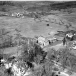
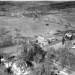
¬†¬†¬†¬†¬†¬†¬†¬†¬†¬†¬† It appears that the Tallmadge family owned the land during this time, because there are records from 1887 documenting the sale of this land by the Tallmadge family.¬† The Tallmadges also owned a 72 acre farm plot in what is now the Hopkins forest to the west of the Hoosic River, and sold that land to Hopkins in 1889.¬† In 1887, according to the president‚Äôs report from that year, a group of men bought the Tallmadge land who planned on building a housing development.¬† A 1889 map shows that Park Street ended at Baxter Road, but the president mentions in his report that the men built Syndicate Road to connect Park Street with North Street. ¬†This road was most likely a dirt path however, because a sketch from 1939 comments that the intersection with Baxter Road marked the ‚Äúend of improved road.‚Ä̬† In the end, nothing came of the housing development and the area was sold to the College.¬† At the same time the Huntoon lot, which included lands east of Syndicate Road and the area that is now Cole Field, was sold to the College, and the land was then used as the college farm.¬† The area was still being used as farmland in 1938, as shown by the aerial photograph below.¬† The photograph shows the Thompson Infirmary and the Cole Field house, and the area that is now Cole Field and the Tennis Courts was plowed in sections of farmland.¬† Besides these landmarks there was very little vegetation, and it appears that one could see Eph‚Äôs Pond from Thompson because the area was not blocked by heavy forestation as it is today.¬† Note also that Syndicate Road is still just a dirt path marked by wheel tracks in this photograph.¬† To the east of this path, where the Syndicate Road woods site now exists, there were a few trees of an indiscernible species speckled along the road.¬†
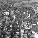
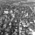
            The next piece of pictorial evidence is an aerial photograph taken in 1962, also shown below.  Here, in only about a quarter century, the amount of foliage in the area has grown at least three-fold since the last picture was taken.  The tennis courts and Cole Field have been constructed, and it does not appear that the Poker Flats field is being used as farmland anymore.  The trees in the area seem to be a mix of both deciduous and coniferous, and at this point Syndicate Road has been paved and has become an official road.  Mission Park and the parking lots behind it were not built until 1971.
            The natural history of the Syndicate Road Woods is noticeable in the terrain of the woods today.  The trees represent those that are usually in existence in old areas of cultivation, especially paper birch, red oak, sugar maple, hemlock, beech and yellow and black birch.  There is little human impact within the woods besides the telephone lines that run north/south along Syndicate Road.  The Syndicate Road woods present an interesting history of a land that was once cultivated and is now very much untouched by human hands.         


