DUE Thursday Sept 15 Continue reading
Author Archives: David Gürçay-Morris
Assignment: Short Map Stories
DUE Thursday Sept 15 Continue reading
Assignment: Book Reports
DUE Friday Sept 30 & Monday Oct 3 Continue reading
Online photo editors
FotoFlexer
http://fotoflexer.com/
Picnik
http://www.picnik.com/
Pixlr
http://pixlr.com/

On your iPad you can use PS Express (Photoshop Express) from Adobe (which should be preloaded on your iPads)
Assignment: 72 Maps in 72 Hours / DUE Monday Sept 12
Over the next three days, create 72 Maps (with a capital “M”). These can be maps of anything — time, space, thoughts, memories. Maps of travel, charts of concerns, work vs. free time, foods eaten. They should all express a relationship between two or more pieces of information.
Assignment: Chaikin, The Presence of the Actor
DUE Thursday Sept 22 Continue reading
ANNOUNCEMENT: THEA 228 syllabus
Gerrymandering and the 2010 Census
 Gerrymandering is an interesting use of maps to political ends. I remember reading about how computers have really changed this, allowing for much more precise (and ludicrous) redistricting in the last two censuses (2000 and 2010) that can target political maps on a per-household basis.
The following article on redistricting in the 2010 Census is a good overview; definitely click-through to the original article for good illustrations and links — the website referenced provides amazing examples of gerrymandering today.
Continue reading
The West Wing — Why are we changing maps?
Hat tip to Rob Baker-White for reminding me of this.
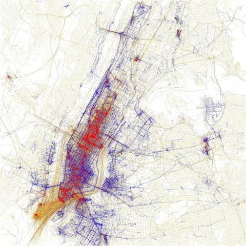
Locals, tourists, and geotagged photos

Locals and Tourists #2 (GTWA #1): New York
Blue pictures are by locals. Red pictures are by tourists. Yellow pictures might be by either.
Base map © OpenStreetMap, CC-BY-SA
